
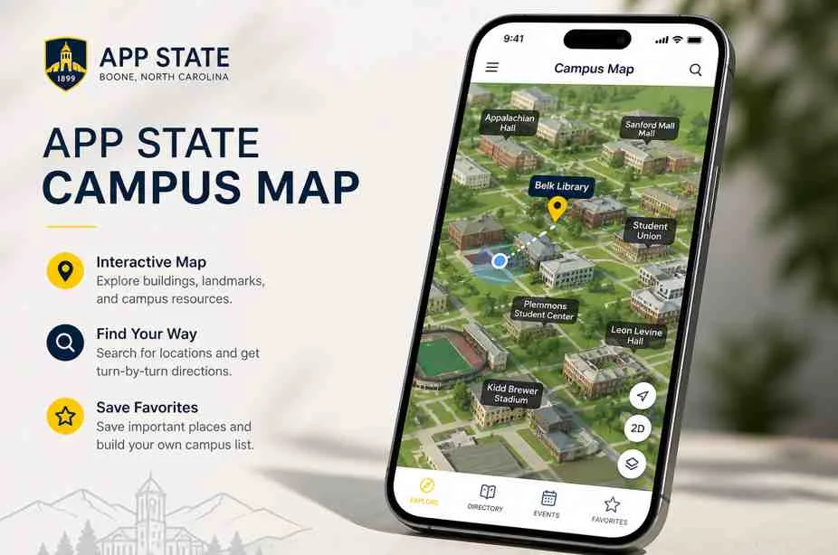


The App State campus map is the official interactive map for Appalachian State University. It helps students, parents, visitors, and staff find buildings, parking areas, walking routes, health and safety locations, points of interest, and campus services from a phone or computer.
The map is most useful when you use it before you arrive, not only after you get lost. In this guide, you will learn how to use it, what to look for, where to park, and how to make your campus visit smoother.
What Is the App State Campus Map?
The App State campus map is an online interactive map made to help people navigate Appalachian State University. It is not just a flat picture of campus. It works more like a digital guide that helps you search places, view campus areas, and understand where important locations sit.
You can use the official App State interactive campus map to search for buildings, parking, dining spots, student services, and campus points of interest. The university also says the interactive map includes wayfinding, parking locations, health and safety information, points of interest, and more.
This matters because App State is not a tiny one road campus. It has academic buildings, residence halls, dining areas, athletic locations, parking decks, offices, and walking paths spread across Boone, North Carolina. Therefore, using the map can save time and reduce stress.
Why the App State Campus Map Matters
A campus map may sound simple, but it can make a big difference during a real visit. New students may need to find classrooms, parents may need to find tour parking, and visitors may need to locate admissions, dining, or event areas. Without a map, small mistakes can waste a lot of time.
For example, a student may park far away from the right building, then rush across campus before class. A parent may arrive for a tour but enter the wrong parking area. A visitor may search for a dining hall but not know which path is easiest.
The App State campus map helps solve those problems before they become frustrating. In addition, it gives users a better sense of how campus connects, which buildings are near each other, and where they should start.
Who Should Use the App State Campus Map?
The map is useful for almost everyone who visits or studies at App State. However, different people use it for different reasons. A first year student, transfer student, parent, guest, and employee may all open the same map but search for different things.
New students may use it to find residence halls, classrooms, dining, and student services. Visitors may use it to find parking, tour stops, admissions, and walking routes. Staff and faculty may use it to find offices, event spaces, and meeting locations.
If you are coming to campus for the first time, do not wait until the last minute. Open the map at home, search your main destination, and check nearby parking or walking paths before you travel.
App State Campus Map Features at a Glance
The best way to understand the map is to think about what problem it solves. It helps you search places, plan walking routes, check parking, and find campus services. The table below explains the main uses in a simple way.
| Map Feature | What It Helps You Find | Best For |
|---|---|---|
| Building Search | Academic buildings, offices, halls, and campus spaces | Students, staff, and visitors |
| Parking Locations | Parking decks, visitor parking, and nearby lots | Parents, guests, commuters, and tour visitors |
| Wayfinding | Campus directions and walking routes | New students and first time visitors |
| Health and Safety Information | Safety related points and campus support locations | Students, families, and employees |
| Points of Interest | Dining, student areas, landmarks, and useful campus spots | Visitors and students exploring campus |
How to Use the App State Campus Map Step by Step
The App State campus map is easier to use when you follow a simple plan. Instead of opening it and randomly zooming around, start with your exact goal. This saves time and makes the map feel less confusing.
Step 1, Search Your Main Destination
Start by searching for the building, office, residence hall, parking deck, or event location you need. If you are visiting Admissions, search that first. If you are attending class, search the academic building name from your schedule.
This step matters because many campus buildings can sound similar to new visitors. In addition, some areas are close together but not always easy to reach by car. Searching first helps you avoid guessing.
Step 2, Check Nearby Parking
After you find your destination, look for nearby parking options. App State visitor parking details can change by purpose, time, and location. Therefore, always check the parking information before you arrive.
The university says visitors are welcome to park in the Rivers Street Parking Deck for an hourly fee. The visitor parking page also says visitors must prepay through the ParkMobile app at the Rivers Street Parking Deck.
Step 3, Plan Your Walking Route
Once you know where to park, check the walking route from your parking spot to your destination. This is important at App State because campus sits in a mountain town. Some walks may include hills, stairs, or longer paths than they first appear on a map.
If you are visiting with family, young children, older adults, or anyone with mobility needs, plan extra time. Comfortable shoes can make your visit much better. In addition, checking the route early helps you avoid feeling rushed.
Step 4, Save Important Locations
Before you arrive, save or note your key locations. These may include your parking deck, first building, dining stop, tour meeting point, restroom area, and final destination. A small plan can prevent confusion later.
This is especially helpful during campus tours, orientation, move in, game days, and busy events. Large crowds can make it harder to stop and search calmly, so having locations ready makes the day smoother.
Important Places to Find on the App State Campus Map
Most people open the App State campus map because they need one specific place. However, it helps to know the main types of locations you may search. These are the spots students and visitors often need first.
Admissions and Tour Areas
If you are a future student or parent, Admissions may be your first stop. App State’s self guided tour page says the route is 1.5 miles, takes about one hour, and highlights notable places on campus. That makes the map very helpful before and during your visit.
The same admissions page gives practical visit tips, such as checking the forecast, wearing comfortable shoes, parking in the Rivers Street Parking Deck, and connecting to visitor Wi-Fi. These simple details can make the campus visit feel easier.
Academic Buildings
Students often use the campus map to find academic buildings before the first week of class. This is a smart habit because your first class day already has enough pressure. You do not want to waste time searching for a room while the clock is ticking.
If possible, walk your class route before classes start. Find each building, check how long the walk takes, and notice nearby landmarks. This gives you confidence before your real schedule begins.
Residence Halls
Residence halls matter for new students, parents, move in days, and guests. The campus map can help you understand where your hall sits compared to dining, classes, libraries, and student spaces. This helps you plan daily routines.
For example, you may want to know how long it takes to walk from your hall to your morning class. You may also want to know which dining area or bus stop feels closest. The map gives you that big picture.
Dining and Student Life Areas
Dining halls, student centers, libraries, and common areas are important because campus life is not only about classrooms. You need places to eat, study, meet friends, and rest between classes. The map helps you find those places faster.
If you are visiting campus, add one or two student life stops to your route. This helps you understand the feel of the campus, not just the academic side. A campus can look different when you see where students actually spend time.
App State Parking and the Campus Map
Parking is one of the biggest reasons people need the App State campus map. A map can show where a parking deck is, but you still need to understand the parking rules. This is where many visitors make mistakes.
App State’s visitor parking page says visitors can park in the Rivers Street Parking Deck for an hourly fee. It also says that after 5:00 p.m. weekdays and at all times on weekends, visitors may park free in any campus lot unless otherwise posted.
However, signs matter. Do not assume every space is open just because it is evening or weekend. Events, restrictions, reserved spaces, and posted notices can change what is allowed.
Visitor Parking Tips
Before you drive to campus, check your destination and parking plan together. If you are going for a campus tour, follow the instructions from Admissions. If you are visiting for another reason, check the visitor parking page first.
In addition, make sure your phone is charged because you may need it for the map, payment, and walking directions. If you use many travel or map apps, you may also want to read this StarUnbox guide on app storing guide and tips so your phone does not get crowded with old app data.
Transportation Around App State
Not everyone wants to drive and park on campus. Some students and visitors may use bus or shuttle services. App State’s transportation page says transportation options are available for traveling within Boone and the High Country, or to and from off mountain destinations.
The same page explains that AppalCART is a fare free bus transit system serving App State, Boone, and Watauga County. This can be very helpful for students who live off campus or visitors who want another way to move around town.
Transfer students are also encouraged by App State to use AppalCart as a free alternative if they live off campus and do not want the cost of a parking pass. This makes transportation planning an important part of using the campus map well.
App State Campus Map for Self Guided Tours
A self guided tour is a great way to explore App State at your own pace. The official self guided tour information says the walking route is 1.5 miles and takes about one hour. That gives visitors a clear idea of how much time to set aside.
If you plan a self guided visit, use the map to understand the route before you start. Look for parking, first stop, dining options, and any extra places you want to see. This helps you avoid walking back and forth too much.
Also, check the weather before you arrive. Boone weather can change quickly, and App State’s admissions page reminds visitors to wear layers and comfortable shoes. A good visit plan should include both the map and the weather.
App State Boone Campus vs Hickory Campus
When people search for the App State campus map, they usually mean the Boone campus. However, Appalachian State University also has App State Hickory. Therefore, it is important to make sure you are looking at the correct campus location.
App State Hickory has its own location at 800 17th St. NW, Hickory, NC 28601. The Hickory campus page also lists campus resources, support services, parking, library support, counseling, writing center, advising, and fitness resources.
This matters because Boone and Hickory are not the same campus area. If you are attending a class, event, or appointment, check your exact campus name before you travel.
Best Mobile Tips for Using the Campus Map
Most people will use the App State campus map on a phone. That makes mobile habits important. A map is only helpful if your phone loads it, your battery lasts, and your internet works when you need it.
Before you visit, charge your phone and close apps you do not need. If your phone is low on storage, map apps and browser tools may run slowly. You can read what does offload app mean if you use an iPhone and want to save space without fully deleting app data.
If you use an older or budget phone, keep your setup simple. The StarUnbox guide on best Nokia apps for speed, storage, and daily use explains why lightweight apps and good storage habits matter on phones with limited space.
Should You Use Google Maps or the App State Campus Map?
Google Maps can help you drive to campus and understand the town around App State. However, the official App State campus map is better for campus specific details. It is built around university locations, parking, wayfinding, and points of interest.
In real life, you may use both. Use Google Maps or Apple Maps to drive to Boone or your parking deck. Then use the App State campus map to move around campus once you arrive.
If you drive often and care about navigation apps, you may enjoy this StarUnbox guide on best CarPlay apps. It covers navigation, music, parking, and safer driving app choices for regular drivers.
| Map Tool | Best Use | Main Advantage |
|---|---|---|
| App State Campus Map | Finding campus buildings, parking, and points of interest | Made for Appalachian State University navigation |
| Google Maps | Driving to Boone, local roads, hotels, and restaurants | Strong road navigation and local business search |
| Apple Maps | Driving directions and iPhone based navigation | Easy for iPhone users and CarPlay drivers |
| Printed Map | Backup during tours or weak signal | Works without battery or internet |
Common Mistakes When Using the App State Campus Map
The first mistake is searching the map only after arriving late. A campus visit feels much easier when you check the route before you leave home. This gives you time to understand parking, walking distance, and your first stop.
The second mistake is ignoring parking rules. A map can show where lots are, but rules decide whether you can park there. Always read signs and check official parking guidance.
The third mistake is assuming every walk is flat and short. App State is in the mountains, and some routes may feel harder than they look on a screen. Wear comfortable shoes and leave extra walking time.
Safety and Accessibility Tips
A campus map can also help with safety and access planning. If you are visiting at night, attending an event, or walking alone, know your route before you start. Stay on clear paths and use official campus resources when needed.
App State’s transportation page lists Mountaineer Safe Walk as a free safety escort service available to students in any main campus building or parking lot. This is useful information for students who may need support moving around campus safely.
If you need accessibility support, check official campus accessibility resources before your visit. In addition, give yourself more time than the map estimate if you need elevators, accessible paths, or lower slope routes.
How Parents Can Use the Campus Map
Parents often use the campus map during tours, move in days, orientation, family visits, and graduation events. It helps them understand where their student will live, study, eat, and spend time. This can make the campus feel less unknown.
Before a visit, parents can search residence halls, dining areas, parking decks, and Admissions. They can also plan a simple route that includes a tour stop, student life area, bookstore, and food stop.
However, do not try to see everything in one short visit. Choose the places that matter most. A focused campus visit usually feels better than rushing through too many stops.
How Students Can Use the Campus Map Better
Students should use the map before the first week of class. Search every building from your schedule and test your walking route. This helps you avoid being late or feeling lost during your first few days.
You can also use the map to find study spots, dining halls, offices, advising, library services, and student support areas. Once you know these places, campus starts to feel smaller and easier.
If you use many web tools for school, you may also like this StarUnbox guide on best OS for web apps. It explains how different operating systems handle web based tools and app like experiences.
Conclusion
The App State campus map is one of the most useful tools for students, parents, visitors, and staff at Appalachian State University. It helps you find buildings, parking, walking routes, dining, safety points, and important campus services without guessing.
For the best experience, use the map before you arrive. Search your destination, check nearby parking, plan your walking route, and save key locations. In addition, remember that official parking signs and campus updates matter just as much as the map.
If you are visiting App State soon, open the campus map today and plan your route in advance. A few minutes of planning can make your campus visit calmer, faster, and much more enjoyable.